Home » Early History » Logging
Logging Impacts on the Manitowish Waters Area and Land Policies
Manitowish Waters was swept up in the national push for aggressive 19th century logging and land speculation. Shortly after the ink was dry on the 1837 and 1842 treaties ceding Ojibwa lands to the government, timber cruisers were systematically surveying the newly available land (especially near robust river systems). By the 1850’s, timber cruisers were sharing with land agents and logging interests both our community’s abundant timber and quality river driving opportunities. In 1878, the Army Corps of Engineersclaimed the Rest Lake dam site as one of the best on the entire Flambeau River system.
In 1862, the original land surveyors documented that pines on Rest and Benson Lakes were soon be taken to market (most likely illegally), marking the start of logging in Manitowish Waters. Modern scholars divide logging and lumber industries into three different phases: 1) river drives of white pines 2) railroad logging and harvesting the remaining white pines, red pine, hardwoods and other trees and 3) post WWI small logging camps using trucks and tractors.(1) Undoubtedly, the different phases of logging in the Manitowish Waters area dramatically defined community development at the turn of the 20th century.

1900's image of Rest Lake Dam and Mississippi River Logging Co. camp
Source: University of Wisconsin Stevens Point archives
Manitowish Waters’ role in regional logging vacillated throughout the late 19th and early 20th centuries. During phase 1 river drive logging Manitowish Waters was regionally dominant by 1888, with the creation of the Rest Lake dam serving mostly the interest of companies controlled by the Weyerhaeuser family. During phase 2 railroad logging, Manitowish Waters became a secondary logging destination and logging slowed compared to other regional communities. Roughly after World War I, phase 3 logging rebounded in Manitowish Waters as exemplified by local loggers and the Loveless sawmill on Alder Lake.
Full History
Phase 1 Logging River Drive White Pine Logging - 1863 - 1906
Since the earliest European explores arrived on the eastern seaboard, North America virgin timber ranked as one of the most prized commodities of the new world. Timber resources, especially in New England were harvested and marketed for more than two centuries before these practices migrated to the Northwoods of Wisconsin. By the 1850’s, emerging logging operations in the Chippewa Valley followed logging practices from New England and sent timber cruisers to Manitowish Waters. (2)
Removal of American Indian land claims needed to be executed before launching large scale logging and lumber operations. The U.S. Government continued a systematic treaty process with the Ojibwa in the Northwoods, securing control of rich lumber and mining lands. The 1837 Pine Tree Treaty and of 1842 Copper Treaty with the Ojibwa ceded timber and mining lands to the U.S. government. Specifically, the 1842 Treaty codified the land cession for what would become Manitowish Waters Township.
Map of Wisconsin treaties, including the 1837 and 1842 treaties with the Ojibwa
Modern historian Ronald Satz’s exhaustive research reveals the disingenuous and manipulative treaty process that ultimately ceded most of the northern half of Wisconsin to the Federal government. In spite of immediate and strenuous objections by Ojibwa leaders, missionaries, and some government agents, the treaties of 1837 and 1842 were enforced to largely benefit Euro-American commerce and settlement.(3) In the late 1840’s and early 1850’s Wisconsin Ojibwa effectively resisted a removal order to Sandy Lake, Minnesota by the federal government, and were later consolidated on Wisconsin reservations.(4) By 1854, treaties had thoroughly divided northern Wisconsin into tribal reservations and government lands, all of which were to be surveyed by the mid 1860’s into numerous, mostly unpopulated townships.(5)
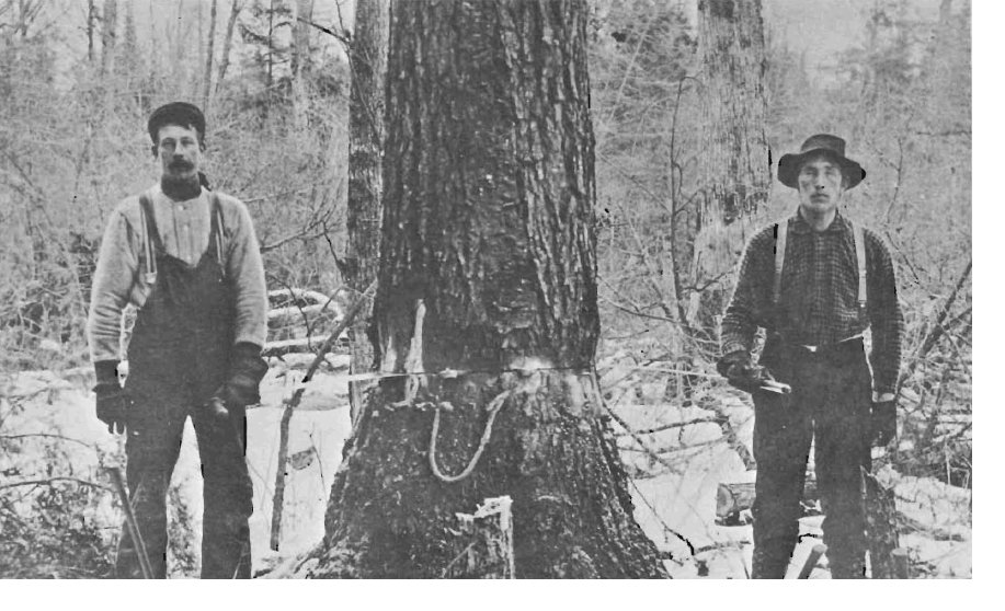
In Eagle River, on the eastern side of what would become Vilas County, logging choice trees and using river drives began in the 1850’s. In Manitowish Waters, the 1862 original survey citations of logs soon going to market were likely easily identified by either fresh stumpage or logs piled on the shore. During the earliest Vilas County logging operations, long log drives from Eagle River to Stevens Point on the Wisconsin River, were matched by longer log drives from Manitowish Waters to Eau Claire on the Flambeau/Chippewa River system.(6)
Accurate land surveys identifying property ownership were critical for legal logging. Land surveyors documenting the township of (what would become) Manitowish Waters in 1862 followed a national model. Government surveyors systematically recorded on bearing or witness trees both township & range coordinates, as well as section numbers. Using an ax, surveyors would blaze or remove some bark of a tree; then scribe the survey data on the cambium or wood of the tree. Additionally, meander lines where survey lines intersected with streams or lakes were marked similarly.(7) Typically 2 trees were marked for each corner sections; the specific species and location of each tree was recorded precisely in field notebooks. These data points were meticulously recorded, providing historic and modern investigators a wealth of information regarding the density and distribution of trees in the Northwoods. Entire maps of Wisconsin original vegetation are available commercially or electronically at the Wisconsin Historical Society based on the original survey data.(8)
1862 Land Surveys documented white pine ready for market at the inlet of Rest Lake and the north shore of Benson Lake near the outlet, “There is in this township a large amount of pine timber much of which is valuable and will very soon be taken to market by floating down the streams which are sufficiently large and are well adapted to the running of lumber.”(9) Since this land survey was ongoing,
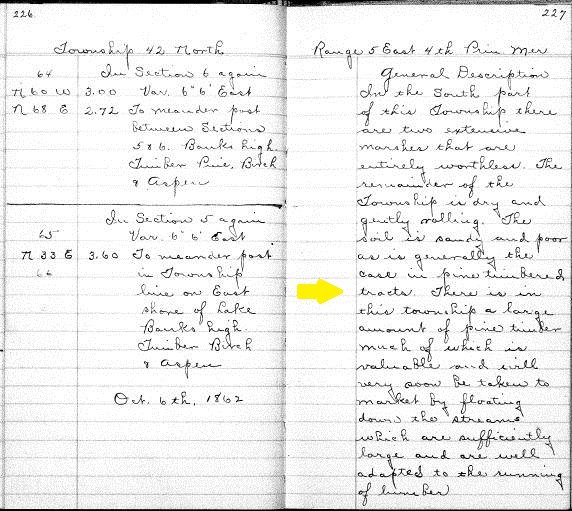
Source: Wisconsin Board of Commissioners of Public Lands http://digicoll.library.wisc.edu/cgi-bin/SurveyNotes/SurveyNotes-idx? type=PLSS&town=T042N&range=R005E
the timber cited by the surveyors was most certainly plundered. Before surveyor documents could be recorded with the government, private timber cruisers had previously conveyed to clandestine loggers the
rich timber resources of our community. Importantly, Manitowish Waters’ excellent river driving conditions for phase 1 logging were obvious to early explorers. Even more notable, the alleged trespassing and timber stealing occurred while the United States was shifting human resources to fight the Civil War, limiting enforcement of timber trespass laws. These timber abuses did not go unnoticed by anxious land agents, speculators, logging interests, universities and out-of-state (absentee) capitalist. In 1865, a land office agent cited, “One third to one half of the best pine lumber on the Chippewa had been cut off by trespassers wherever it was most accessible.”(10)
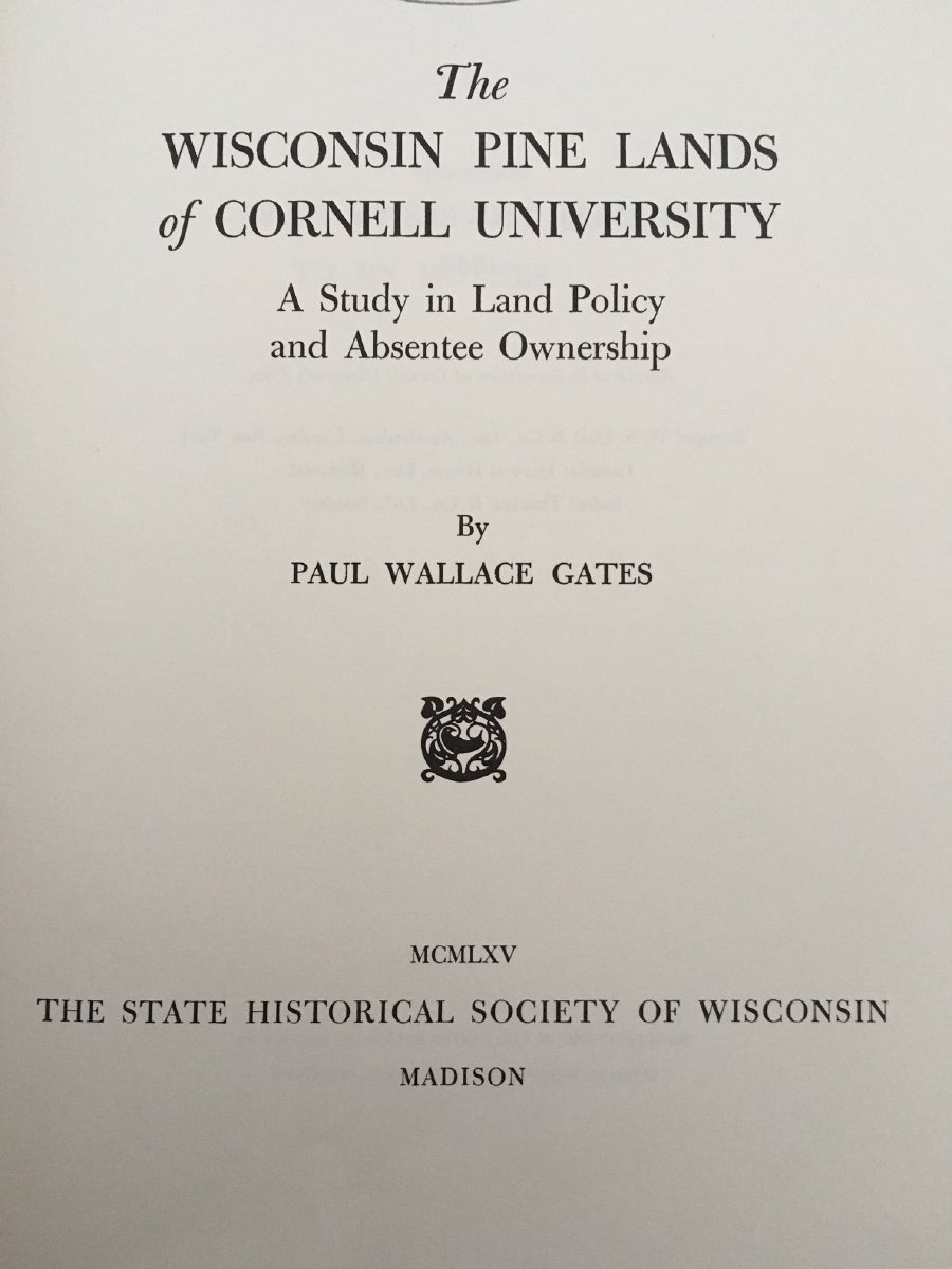
Competition for the newly surveyed land in the Northwoods was both intense and rigged. The U.S. Government lacked cash resources to promote settlement, infrastructure and agriculture education; turning to granting government lands to qualifying interests as a subsidy for development. Railroads enjoyed numerous railroad grants from 1850-1870’s. The Wisconsin Central or Soo Line railroad grant most impacted Manitowish Waters. In 1862, both the Homestead Act and Morrill Land Grant Act for agricultural colleges were passed opening more preferred access to government lands. Importantly, Cornell University was able to acquire 500,000 acres of land in the Chippewa Valley to sell for agricultural education in New York.(11) (12) Cornell and Wisconsin Central Railroad lands stretched to Manitowish Waters.(13) Previously established logging interests and mill owners hated the new land grants, because central Wisconsin mills and loggers now had to share access to profitable government lands.(14)
The notion that the 1862 Homestead Act empowered ordinary Northwoods citizens to fairly benefit from 19th century government land policy was laughable. Most northern Wisconsin settlers were handed a “fixed deck”; assuming new statutory access to “free” land, would-be homesteaders soon discovered uncooperative land agents, who enjoyed near monopolistic control of government lands. The collusion, bureaucratic manipulation, price fixing, and specially interest abuses that followed created a powerful cartel; defining both land policy and logging into the 20th century.(15) Manitowish Waters pioneers facing days of travel to a county seat to claim their homesteads could be easily stonewalled by land agents. Pioneers seeking “ownership” of their already established homesteads risked being identified as squatters on land already acquired by members of the land cartel. Pioneers would then need to legally establish “squatters rights” under the Preemption Act from 1841-1891.(16) Early pioneers faced additional obstacles in owning their homesteads, including: liability for back taxes, recording fees, fines, and professional support to navigate survey complexities to ensure a deed’s accuracy. Not surprisingly, local pioneers and logging operators “accessed” timber on the vast properties of absentee land and lumber barons, trespassing to capture their slice of the “American Dream.”(17) Later, as communities sprung-up in counties where the “Pine Land Ring” held significant lands, county agents retaliated with manipulative tax policies, high public salaries, and new public works projects which cut into cartel profit margins. Bitter county tax battles followed with both sides engaging in ugly practices.(18) Honestly, in-depth analysis of late 19th century Northwoods land practices provides the perfect scheme for a rural version of the popular board game Monopoly.
From the 1850’s until the first documented Rest Lake dam construction in 1888 timber cruisers were moving through the region on a regular basis to give feedback to land agents who served: speculators, universities, railroads, and logging companies. Ongoing timber cruiser reports empowered land agents to target the best lands for purchase leaving the marginal and waste lands for homesteaders and the government.
Men who made it their trade to examine forest land for others were known as "land workers "or "timber cruisers." Some were in the employment of a lumber or land company; others were independent business men who sold their information to the highest bidder. Ordinarily the independent timber cruiser also had some other occupation, such as running a logging crew, scaling timber, or guiding prospective settlers and sportsman. In the lake states the examination of timberlands became a highly skilled trade. As a class, according to a member of the Wisconsin's First Forestry commission, the cruisers had "remarkable intelligence" and a "great stock of empirical information regarding such matters as fall with in the immediate scope of their business."(19)

Timber Cruiser blazing old growth trees Copywritten image published with permission. oldpaperart.blogspot.com

Historic axe blaze from either a timber cruiser or trapper near North Lakeland Discovery Center trails
Manitowish Waters Historical Society Collection
The most successful and powerful land agent in the Chippewa Valley was Henry C Putnam. Putnam, also could delay land purchases by bureaucratically manipulating and holding records from sale.(20) Thus allowing preferred customers to purchase land later, thus avoiding taxes and other costs. For all of his maneuvering, Putnam took a percent of the land deals to pay his timber cruisers, protect lands from timber stealers and be compensated for his special expertise. With all of their power, in 1874 Ezra Cornell and Henry Putnam continued to struggle with timber stealing both in the forest and in court proceedings, because judiciaries were sympathetic to locals over out of state speculators.(21)
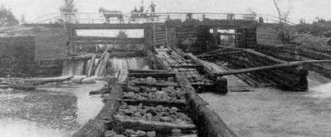
At first glance, the minimal impact of early railroads on logging practices in the Manitowish Waters area seems illogical. In 1874 the Wisconsin Central (Soo Line) from Ashland, WI to just south of Fifield, WI marked the first regional railroad that impacted the Manitowish Waters area. The entire Soo Line was completed by 1877 linking the new railroad with the Flambeau River communities of Park Falls, WI and Fifield, WI. The Wisconsin Central (Soo Line) reached Ashland, WI to the north and Marshfield & Stevens Point, WI to the South.(22) Importantly land grants from the Wisconsin Central reached the western border of Manitowish Waters, suggesting early railroad influence. In practice, the Wisconsin Central or Soo Line provided limited service for phase 1 white pine loggers in Manitowish Waters. Fredric Weyerhaeuser’s Pool or Syndicate of 100 silent partners worked with Putnam and other land agents to monopolize much of the white pine along the Manitowish River basin.(23) The Mississippi River Logging Company, the Chippewa Lumber and Boom Company along with a few other Eau Clare based logging interests continued their domination of white pine logging on the Chippewa Basin.(24) Consequently, Manitowish Waters’ area log drives were some of the longest in Wisconsin. Historian Michael Dunn reported, early dam construction at Rest Lake required materials moved by rail to Park Falls, WI to be rafted upstream to the dam site in 1887-88(25)
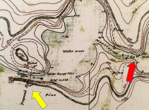
In 1878, the Army Corps of Engineers conducted a series of surveys along to the Chippewa River to facilitate dam construction mostly for phase 1 river drive logging and flood control. Captain Charles Allen led these surveyors, but his assistant Mr. J. H. Dager lead the survey for the Rest Lake dam. Dager and his men proclaimed the Rest Lake dam site as excellent, able to hold back 25 feet of water.(26) Interestingly, after extensively researching and documenting a 25 foot head of water at the original dam site located a few meters downstream of the outlet of Vance lake, in 1880 the U.S. Congress changed the height of the dam to 15 feet.(27) Ultimately, the dam was moved upstream to its present location at the outlet of Rest Lake, likely because a
Source: Charles Allen Expedition 1878, Army Corps of Engineers
Yellow arrow indicates original dam site with 25 feet capacity
Red arrow indicate actual dam site with 15 feet of capacity
local resident like Peter Vance might have suggested the goal of a 15 foot dam could be achieved at the Rest Lake outlet site with a fraction of the construction. Later, two other phase 1 river drive dams were constructed upstream of the Rest Lake Dam on the Manitowish River: one at the outlet of Boulder Lake on Highway K and another creating a flowage below Fish Trap Lake. A lesser known dam was authorized for construction on the Trout River rapids by the modern golf course, but its’ historic status remains unclear.(28)
In 1884, Peter Vance claimed to settle on Vance (Dam) Lake after traveling by canoe from Menomonee WI or Eau Claire WI as a timber cruiser. Suggesting Vance worked for the Weyerhaeuser Pool and thereby avoided rail transport. Vance likely was one of the last few timber cruisers sent before the construction of the first Rest Lake Dam. Some histories suggest that Peter Vance and his Ojibwa wife Sarah Mitchell Vance were the first long term settlers of Manitowish Waters during the logging era.(29) Recent research strongly suggests that Dan Devine and his Ojibwa spouse Kate settled on Clear Lake at least 5 years earlier, making the Devine family our communities’ first logging era settlers.(30) Dan Devine Sr. was a Civil War veteran who reportedly, worked for logging companies, guided, trapped extensively, operated a resort/camp and developed strong ties to traditional Ojibwa practices.
The ownership, construction, location, regulatory authority and jurisdiction of the Rest Lake dam has been debated since its inception. By 1916, the early debates regarding the Rest Lake dam were mostly settled by the Wisconsin Supreme Court. Judicial documents reveal in 1887, the Chippewa River Improvement and Log Driving Company under the ownership/authority of Charles Henry received legislative charter to build the Rest Lake Dam.(31) Construction of the first dam concluded in 1888 and was built by Chippewa River Improvement and Log Driving Company. At the same time, the most historians support Chippewa Lumber and Boom Company claims to have run logging operations, controlled dam operations, and occupied a camp just south of the Rest Lake dam. Frederick Weyerhaeuser actually “owned” or controlled both the Chippewa River Improvement and Log Driving Company and the Chippewa Lumber and Boom Company.(32) Continuing this ownership trend, some references from Paul Brenner suggest the Weyerhaeuser’s Mississippi River Lumber Co. also dominated timber ownership and phase 1 river drive logging in the area.(33) Recent research of deeds in the area of the Rest Lake dam suggest Weyerhaeuser’s Mississippi River Lumber Co. actually owned the land on Rest Lake until 1902 and only transferred ownership to the Chippewa Lumber and Boom Company because the Mississippi River Lumber Company was to be dissolved in 1909.
For the purpose of clarity and consistency going forward, the Weyerhaeuser entity controlling the Rest Lake dam properties will be cited as Chippewa Lumber and Boom Company to align with nearly all modern historic accounts. Acknowledging that as the lead entity of the “syndicate”, Weyerhaeuser’s Mississippi River Logging Company owned the Rest Lake dam area land and much of the land in the region from 1887 until the early 1900’s, during virtually all of the Phase 1 logging.(34)(35)
Rest Lake Dam c. 1902
Manitowish Waters Historical Society Collections
The size, engineering, and capacity of the Rest Lake dam are disputed among local historians. Paul Brenner’s research suggests in 1888 a low dam at Rest Lake was constructed and later replaced by a high dam by 1892(36) While Michael Dunn suggests:
“In 1887 the state legislature authorized the lumbermen to build a dam there to pen up waters of the chain for logging and river driving. In 1887-88 crews built a camp below the dam site and began
freighting in the first supplies upriver from the railroad at Fifield and Park Falls. They also began grading the earthworks on either bank and began building rock crib and timber dam tall and strong enough to hold back water fifteen feet deeper than the chain had ever seen before!” (37)
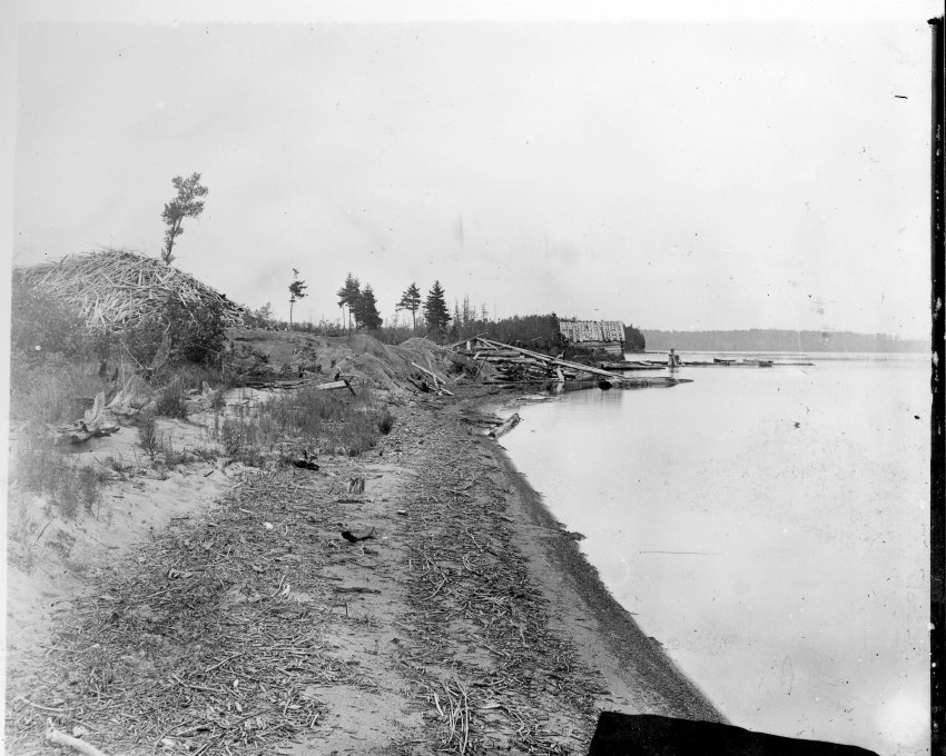
In 1902, Ironwood resident, James Albright recorded that Fox Island was eroding from the dam raising water more than 12 feet for logging operations. In addition to citing extreme erosion, Albright estimated the size of Fox Island to be 20 acres. Today, tax records reveal that Fox Island is slightly larger than 9 acres. Early dam operation in support of logging ravaged the original shores of Manitowish Waters.
By 1914 early court documents regarding a dispute between Manitowish Waters’ residents and the Chippewa & Flambeau Improvement Company regarding dam operations evidenced the dam was in terrible disrepair and needed to be fixed immediately.(38) Local historian Michael Dunn observes many of the repair issues regarding the Rest Lake dam were resolved in the 1920’s, “The reservoir company replaced the wooden dam with the present masonry dam in the mid-1920's.”(39)
Even though, railroad construction of the Chicago Northwestern reached Lac Du Flambeau in 1888 and Powell and Manitowish in 1889, phase 1 river drive logging dominated Manitowish Waters logging until at least 1900. The final river drives were concluded in 1904, as the Milwaukee Road spur reached the northern part of the Manitowish chain in 1905, joining the unique Little Star Lake spur built for the Flambeau Lumber Company which had begun logging operations in 1900.
Phase 1 logging required the Rest Lake dam to maximize white pine logging and river drive operations. Earlier logging was limited due to varying spring runoff and occasional make-shift dams. Possibly by 1888, and certainly 1892 the Chippewa Lumber and Boom Company could hold back 16 feet or more of spring runoff to drive logs. Actually, logging companies would release and rebuild dam reserves throughout the spring to flash logs downstream. Court Records reveal that from April until June water levels would rise and fall several feet per day with no warning due to these practices.(40)
Rest Lake Dam Logging Camp operated by Mississippi River Lumber Co. 1887-1902 & Chippewa Lumber and Boom Co. 1903-1912.
Flancher Collection from Manitowish Waters Historical Society
The most intense white pine river drives in Manitowish Waters took place between 1888 and 1897.(41) The Chippewa Lumber and Boom Company camp where the Pea Patch Saloon property is currently located was the area’s most documented lumber camp. The camp was built using the classic Dingle design from the logging traditions of Maine. The Dingle was a cold space that essentially linked the bunkhouse to the cook house/dining area. The river drive camps looked like one big building but it had three distinct internal rooms.(42) A Dingle took about 2 weeks to build and could house dozens of lumbermen mostly during winter and spring. An early sportsman adventurer traveling from the rail stops at Eagle River to Manitowish by canoe describes the Rest Lake camp in 1890:
“The dam was 3 miles below and we were trying to reach it before dark. We made it, but had no time to lose, in a half an hour after we pulled the latch string on the dam-keepers shack, we sat down to just such a meal as a logging camp cook always knows how to spread before sportsman, who have been working hard and living on fish and grouse straight for a week. We arose the next morning at the usual rise in time and logging camps, 2 o'clock, and long before daylight we were ready to start.” (43)
Today, residents and visitors in Manitowish Waters can enjoy drinks and dining on the same historic logging camp property at the Pea Patch Saloon. Looking toward the dam while seated at the Pea Patch, imagine the experiences of 1890 tourists at a river drive lumber camp. If you have difficulty imagining the logging era, just look at the top of the bar for dozens of images celebrating historic Manitowish Waters. Owners Lisa (LaPorte) Hopkins and her husband Barry encourage visitors to use the deck or walk toward the river and witness the many pilings that remain form the logging era. Lisa’s uncle Cal LaPorte claimed that the LaPorte family led the last river drive of white pines in the early 1900’s.
The unique culture and traditions of river drive logging camps, as well as the dangerous log drive journey to Chippewa Falls or Eau Claire are chronicled well by local historians Paul Brenner and Michael Dunn. Where ever possible, the citations of these historians will be included to illustrate the Manitowish Waters area river drive logging. Below, Michael Dunn provides an excellent overview of seasonal logging practices supporting Manitowish Waters phase 1 white pine river drive logging:
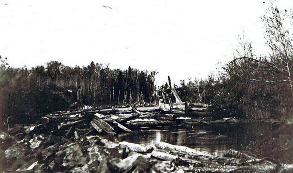
The Chippewa Lumber and Boom Co. opened the logging age here. In 1892 CL&B forces built the Rest Lake dam with heavy timbers, three spillways and huge iron bullwheels to control the gates; the same year its men also built a steamboat with a backbone of tamarack and cedar ship knees hewn on the Island Lake shore. For the life of the CL&B activities here, the most exciting event of the year was the log drive. For several weeks early each summer pine logs were sent through the spillways in great bunches and washed downstream with huge gulps of penned up lake water. The river might

River Rats or River Pigs cleaning-up a log jam
Creator: Malcolm Rosholt Publisher: Rosholt House 1980 Submitter: McMillan Memorial Library OCLC number: 06829658
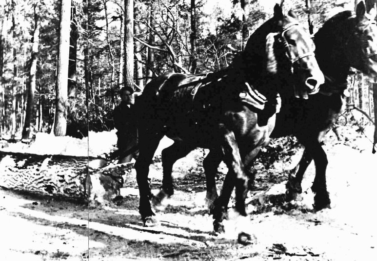
then be a solid mass of logs for many miles. Skilled drivers prodded them along. Leading and trailing the drives were wanigans or cook boats, built below the dam for each year's drive. It took almost all summer and the efforts of up to two hundred men to push the drive all the way to its Chippewa Falls area destination. The rest of the year lumberjacks who lived in long, low, log camp buildings below the dam labored to replenish the log supply held behind the dam in preparation for the next season's drive. They took only the finest of pine, so light that it could float indefinitely and was called cork pine; in the winters teams and sleds pulled the newly felled timber to the icebound shores; in summer giant wheels were used. On the waters of the lakes, raised up to sixteen feet above their original level by the new dam, and thus spreading over a much wider area, the steamboat worked almost round the clock to shepherd huge rafts of logs to the dam. The boom, however, could not go on forever, and by the early 1900s and certainly by 1906, the crude little paddle wheel steamer, its whistle stilled, lay pulled up on the shore where modern day water skiers stage their shows. A few families clustered around the dam, which deteriorated and even was left open for a while; the landing where boats met travelers was located on the present Ilg property. The horses, ponies and wagons were kept there and a man named James McKinney kept a tavern there before 1910.(44)
Clearly, the fledging community of Manitowish Waters was emerging from the Chippewa Lumber and Boom operations and the expanded chain of lakes resulting from the Rest Lake dam. Rail access to nearby Manitowish and Powell rail stations provided both supplies and passengers to support a budding tourist industry all before 1900.
Historic logging expert Paul Brenner also shares phase 1 river drive logging analysis, with specific insights regarding the stamping, driving and scaling of white pines for market. Below is Brenner’s narrative from a recorded interview:
Now getting back to the oldest logging, the stuff that was sleighed to along the lakes and the rivers in our area the Manitowish River and the Rest Lake Chain and stuff like that. The loggers built a series of dams to raise the water up considerably and they had one at Rest Lake which is where Manitowish Waters is now. They also had one below Boulder Lake which is near the junction of highway "H" and "K". And they also had one further up stream called the Fish Trap Dam which raised the water all the way up to High Lake. Now I think they raised the water up in the fall so that once they started getting ice they could put logs right on the ice if they could get to the lakes because of the banks. But if not then they decked them along the edges of the lakes and rivers and then when the ice went out in the spring they'd roll the logs into the water and they'd float down ever so slowly but they'd float down. At the Rest Lake Dam there is, I have a series of pictures here that show the Rest Lake Dam. Unfortunately not where we could see any logs going through it. This other picture is the Boulder Lake Dam. I'm sure this is when they were using it but they don't show any logs coming through it. So they'd keep the gates closed on the dam until they'd get a head of water and a load of logs behind it. And then they'd open up the dams and what that caused was raise the river down below the dam for quite a ways and it would sluice the logs down over maybe so
Log jam and hoist/boom bewteen Vance and Sturegon Lakes
me bad spots. Then the rest of the water would be deep enough that the logs would float ever so slowly. They figured one log out of ten never made it to the mill because they either sank or they got stuck in places where they couldn't get them back into the main current.
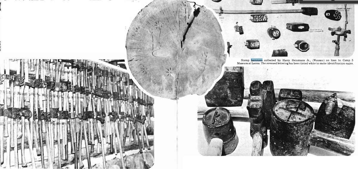
Now at the time that all these dams were built there were many companies using the same rivers and lakes and they had to have a way of sorting the logs after they got down to where the mills were. In our case the logs went all the way down to Eau Claire and Chippewa Falls. This particular picture shows a man that was both scaling the log which means that he was measuring the board feet that were in the log and at his toe you can see a small hammer. These hammers have raised letters or numbers or all kinds of things. They could be anything. There were thousands of them registered just in this one lumber district and there were ten or twelve lumber districts in Wisconsin. Both ends of the logs were usually marked anywhere from one to ten times depending how big the logs were. By this method when the logs got down to the mills they were able to sort them out, each company having their own marks.(45)
Importantly, Michael Dunn has additional insights and details regarding river drives that corroborate Brenner’s narrative:
Every few days a gate in the dam was opened and a large batch of logs was sluiced through, followed by a dose of water large enough to assure that the logs would float freely downstream but not enough to wash the logs ashore along the river's wandering course. The sluicing lasted only a few weeks, but took place every spring for ten to fifteen years.
As the logs moved downstream, log driving crews shepherded them to prevent jams and to get stray logs back into the flow. The most colorful fixture of the log drive was the wanigan that accompanied the drive. It was the kitchen boat that was built on the flat below the dam: A scow with a house on top to enclose the kitchen, supply space and sleeping quarters for the cook. Each evening the log drivers would gather at the wanigan for a hearty supper and maybe a little singing before they separated to sleep in little tents or just under the stars. All the dams below the Rest Lake Dam had gates big enough to allow it to be sluice through, guided by its big oars.
The logs were boomed and sorted and fed into the huge sawmills of the Chippewa Falls or Eau Claire area, or some of them were sent on toward the Mississippi mills, and the wanigan was abandoned or dismantled.
Erosion from dam operations during the logging era
Flancher Collections Manitowish Waters Historical Society
Back at the dam here, when each drive was over, two and a half billion gallons of water had been penned up and then released; the lakes were down to their original pre-1887 levels; and raw, ugly scarred new margin of erosion and stumps marred fifty some miles of the shoreline.(46)
As the phase 1 river drive logging came to an end in Manitowish Waters at the beginning of the 20th century, Paul Brenner shares evidence he discovered in 1982 corroborating both Weyerhaeuser’s influence and the end of the river drive phase:
Paul Brenner found a log in Rest Lake, in 1982, which he recognized as having been cut by the Chippewa Log and Boom Company of Chippewa Falls, WI. The mark was registered on October 2, 1902. The company camp was located just below the dam, behind the present day Pea Patch restaurant.(47)
The transition between phase 1 river drive logging and phase 2 railroad logging blurred at the turn of the 20th century. Many practices, cultural behaviors, traditions, and technologies migrated to phase 2 railroad logging. One of the most storied narratives regarding lumberjack traditions were the antics of hard drinking and brawling loggers. In the winter of 1895, during the transition between both phases of logging, an early sportsman, E. Hough documented the drunken and violent behaviors he witnessed while visiting Manitowish and Woodruff.
While traveling from the town of Manitowish to Circle Lily Lake to check a trap line with local guide Fay Buck, the author shares:
On this first day, as we were going along the logging trail which lead out of Manitowish, we came upon a man lying on his back on the snow in the middle of the road. He was motionless, and when I went up to him I thought he was dead, but at length saw he was only paralyzed by pine woods whiskey. He was dressed in the usual Mackinaw clothing, and thanks to which for the fact he was not frozen stiff. After much trouble we got him awake, and found he was only one of the tough "lumberjacks " common to the region. (I think the working population of the Pine woods is the lowest, filthiest and most degraded class of man I have ever seen in any part of the United States).
"I jist sit down for wance in a woy, "said this specimen, who proved to be an Irishman."D ye mind, I wuz waitin’ fur a felly, see? "
We saw that to leave him alone was to allow him to freeze to death, so we drag and drove him along with us for a couple of miles, till we came to the logging camp, where we left him. As the keen air and exercise of walking (which latter in his case was violent) began to eliminate some of the effect of the awful liquor he had been drinking, he became first apologetic, then explanatory, then talkative, and finally belligerent. Northern country whiskey has a couple of fights in every drink, and it's chief characteristic began to show in our newly discovered friend.(48)
This revealing narrative then degrades into a nasty exchange of swearing (----), which illustrates the deep nativist and ethnic prejudice which was common at the turn of the 20th century.
"An’ pfwhat moight be yer name, ye yeller-headed – – –? "He said to me, as I walked ahead. "An’ pfwhat is thim t'ings ye'er carryin over yur shou’hlder?, (meaning the skis.)
“they’re my skis, you read headed – – – –, "said I to him, cheerfully.
"Umph-humph, "Said he, and lapsed into thought for a while, at last resuming: "skees, it is, is it, eh? Thim is thim skates the Norwaygins uses, eh?"
I told him he was correct, and for quite a while he was silent, but at length broke out with a snort of rage.
"Shore, if I’d a gun I kill ye, ye yeller-headed --------,” said he, “There’s Norwaygins enough, in this yer counthry now!" This he said with an air of deepest conviction and I could only admit that he being a resident of the country, must be better acquainted with its condition and requirements than myself.(49)
The behavior described above fueled some reform minded citizens to support temperance or even prohibition movements in this period and beyond. In the short and long term, it would be safe to assume that “dry” advocates were a minority in Wisconsin’s Northwoods.
E Hough, continued his travels to Woodruff, to pick-up a mail order camera and catch a train to Star Lake for more 1895 winter adventures. His time spent waiting for his camera revealed more lumberjack behaviors and culture which would cause “civilized” citizens’ great pause:
The village of Woodruff, Wisconsin is in the fishing season the port of entry for Trout Lake and the Manitowish muscallunge waters, and at that time it has a sort of transient life. In the winter season it is dull, squalid and tough with a toughness not easily to be paralleled. I think there is no population in America of so low a grade as the riff-raff of the lumbering regions. The small towns of the Western frontier are tough, but they have a brilliant wickedness which gives them a fascination of their own. The logging town is low, sodden, degraded, and does not rise to the dignity of wickedness. The inhabitants, or the transient loggers who enable the inhabitants to live, are assorted foreigners of beast-like habits and tendencies. Cleanliness is unknown. Dirt, vulgarity, depravity, low-downness are the characteristics that meet you. One can mingle with clean wickedness without personal discomfort, but dirty vulgarity is far worse in consequence. Even the style of fighting (and where cheap whiskey abounds fighting must ensue) is of poor type in the pinewoods. In the Rockies we used often to see gentleman who were in there cups having disagreements, and pull their guns and shoot it out like gentlemen, others not interfering. In the lumbering regions the weapon is the fist and the hobnail. Etiquette demands that when one has knocked an enemy down he shall stamp upon him or pound him. Often half a dozen will set upon one man, and customs seems to dictate that all ones friends shall help him pummel a single adversary. Woe be to the “river jack” who starts into a fight without a "gang" behind him, for if the other man has a "gang "with him they will all go into action as soon as it seems safe. There are many nationalities, and the feuds between the different clans always break out at the bar where the red-eye moveth itself all right. All the hotels are small, and the bar in each is the biggest half. Quiet is there unknown. As I could not personally approve of the style of fighting customary in this region, I was a good deal bored during my three days stay at Woodruff, as I was waiting for my camera to come in from Chicago.(50)
E Hough’s vivid lumberjack descriptions in the woods and taverns pulls back the veil on loggers’ behaviors and culture. Contextualizing, Manitowish Waters historian Michael Dunn’s respectful insights regarding the popularity of area lumberjack taverns: “…the great logging days, a swashbuckling era during which you might have seen stuck into the ground in front of a tavern the pike-poles or canthooks of a hundred or more lumberjacks drinking inside.”(51)
Arguably, lumberjack violence, surliness and unrest may have a variety of root causes: 1) many logging camps were organized in company towns paying wages in “company currency or tokens” which could
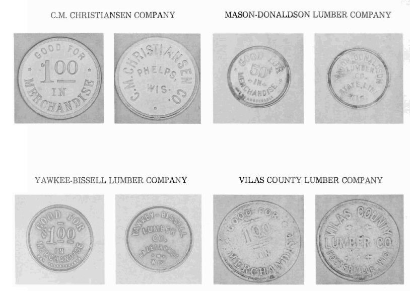
Vilas County and Yawkee-Bissell Lumber Companies were area logging operations that paid employees with company "currency"
Creator: Malcolm Rosholt Publisher: Rosholt House 1980 Submitter: McMillan Memorial Library OCLC number: 06829658
only be used under the monopoly of the logging camp. Thus, keeping loggers tethered to the logging company and making economic mobility difficult. 2) The abundance of both commercially manufactured and locally distilled moonshine tended to escalate violence and poor choices in logging areas. 3) Proper hygiene, even by 19th century standards was a serious challenge. The lumberjack Sunday tradition of boiling clothes and perhaps bedding proved to be the most effect hygiene practice to limit the scourge of lice, scabies, and other human borne parasites. “Pants rabbits”, “crotch crickets” and “seam squirrels” cohabitated with many loggers during their tenure in the wilderness. 4) Prostitution was also present in logging areas, amplifying the ravages of diseases in lumber communities. In 2010, an environmental historian completing his doctoral dissertation shared that an episode of eye syphilis had plagued a large logging camp during late 19th century in eastern Washington State. Investigations by the camp doctor revealed the disease bearing vector for the outbreak was a communal wash cloth for washing logger’s hands and face. The wash cloth hung by a window above a logging camp wash basin, creating a moist and cool environment sustaining the offending bacteria. 5) Constant dangers from logging and river drives may have taken a psychological toll, leading some loggers to adopt a “devil-may-care” approach to life. Masking a deeper fear of death or crippling injury, loggers might live in the moment, embracing a more violent lifestyle to match their circumstances.
Please excuse the unvarnished portrayal of laborers in lumber camps, possibly undermining the romantic view of lumberjacks often shared in books and films. The cases above were not universal, and some camps were fair, clean, more or less moral and shared profits with workers. Sometimes nuclear families operated logging camps with a few hired loggers creating some exemplary logging communities.(52) The intention of writing about the darker side of logging is to cast serious doubt on the “Disney” version of lumberjacks being self-made men, living in a wilderness utopia, ultimately creating an egalitarian world where they live happily ever after in their own virgin forest home. The truth is, these men (and women) worked very hard, in challenging conditions, for little long term profit, against economic and political forces that made realizing the American Dream a true battle.
Interestingly, in the publication, Boulder Junction The Early Years 1880’s to 1950’s, one historic account claimed that “ ‘River pigs’ were, the north country’s counterpart to the Western cowhands who presided over cattle drives. These northern woodsmen herded unruly logs downriver to their destination.”(53) E Hough’s article in 1895 contrasts loggers behavior and violence as being far worse than Western cowboys.(54) In both these references, the authors link phase 1 and phase 2 Northwoods logging with American Western frontier. Of further interest, the U.S. Census marked 1890 as the end of a continuous frontier line, as the great American Western frontier had been tamed by the completion of railroads and settlement practices. With the arrival of railroads to the Manitowish area in 1889 the settlement of this pocket of the Northwoods frontier mirrored the American West.
Famed historian Fredrick Jackson Turner from the University of Wisconsin suggested in an 1893 groundbreaking speech entitled, "The Significance of the Frontier in American History", that American democracy was mostly a product of the frontier experiences.(55) Turner further argues, “… the frontier is the outer edge of the wave-- the meeting point between savagery and civilization.”(56) Turner’s late 19th century scholarship guided frontier analysis for nearly a century. When Turner gave his 1893 speech, Manitowish Waters was still a wild frontier, still evolving; even with limited 19th century rail access, institutions of democracy will not take root here until the 20th century.
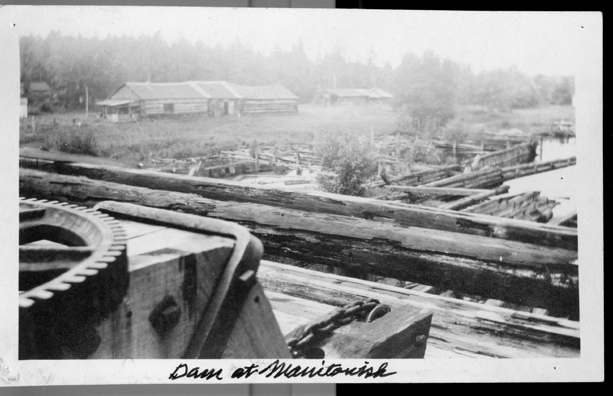
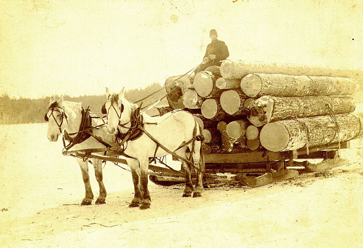
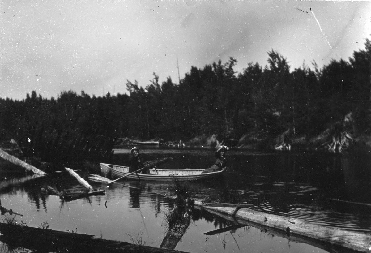
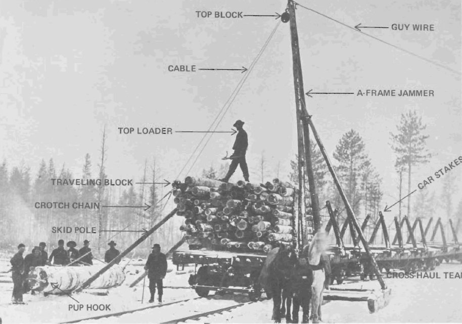
An important logging practice that facilitated both phase 1 river drive logging and phase 2 railroad logging was the use of steamboats to raft logs over slack water on the Manitowish chain to be sent either over the dam or loaded by hoist to rail cars. This practice worked well with white pines, but red pines, hardwoods and even softwoods like birch would ultimately sink. Loggers attempted dry logs to help them float longer, but the possibility of insect and grub infestations motived loggers to deliberately move their timber the nearest rail hoist. The bottom of Manitowish Water’s lakes are littered with logs that never made it to market. Cal LaPorte shared that during phase 3 logging residents would take 20 foot pike poles and probe the lake bottoms discovering enough timber to mill into homes and businesses. Jokingly, he referred to the lake bottoms as “our Home Depot.”

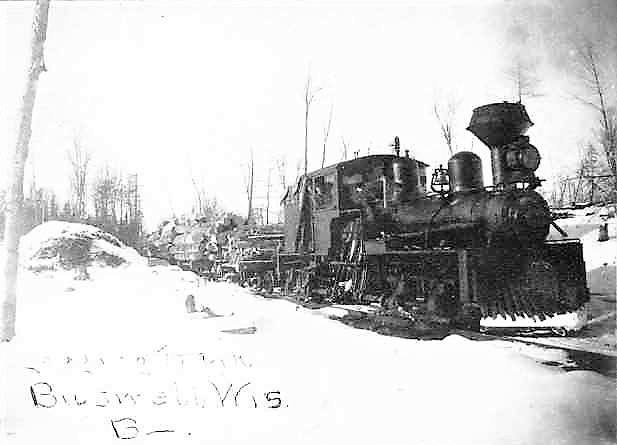
Rice Creek Bridge
Provider's name: Ticket to Buswell Facebook page URL: https://www.facebook.com/TicketToBuswell/photos/a.1635977279981942.1073741829.1635294486716888/1681200825459587/?type=3&theater
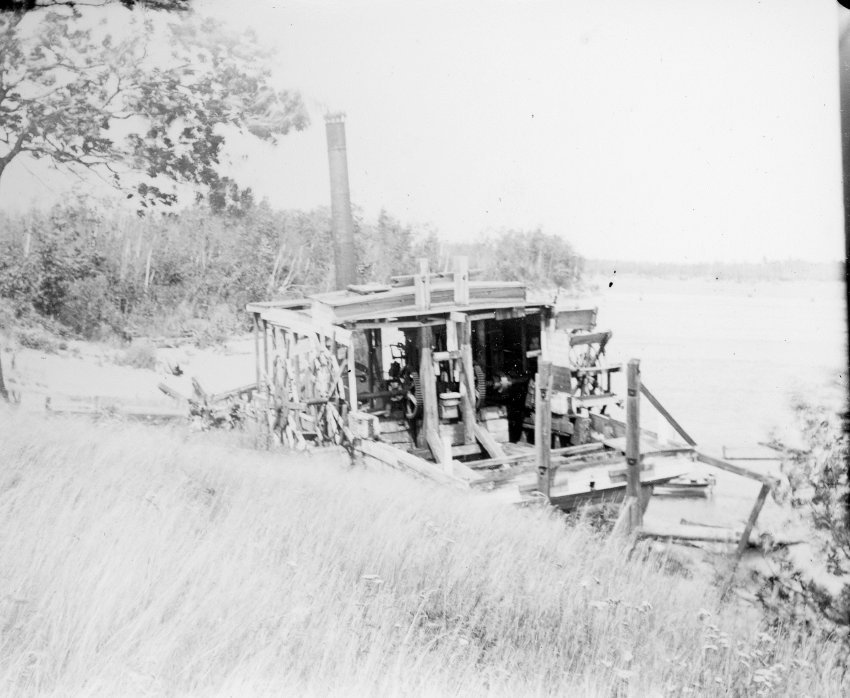
Michael Dunn and Paul Brenner have written extensively regarding steamboat use on the chain of lakes. Dunn’s analysis of the three hoists on the Manitowish Chain illustrates the importance of both steamboat transport and Rest Lake dam operations to phase 2 logging:
Two logging railroad spurs were pushed to the shores of the chain on Rest and Little Star lakes. Norway pine and other logs were put into the lakes of the chain and rafted by gas or steam tugs as quickly as possible to these two railroad landings and hoisted onto flatcars. These other species do not float as well as the white pine, so there was always a sense of urgency in rafting them, and rafting sometimes went on day and night. There was also a side track at Rice Creek Bridge where a self-propelled log loading crane could come and load logs rafted from the lakes of the chain or floated down from above Big or Round Lakes.(57)
Paul Brenner’s interview adds additional insights on the importance of steamboat operations to efficiently move logs on water lacking strong current during both phase 1 and phase 2 logging:
…in order to get the logs to the Rest Lake chain which was a series, I think, of ten lakes or whatever it was, they had to, there wasn't enough current that went through the lakes so they had to have booms where ever the main rivers came in to the lakes. And at these booms then they'd make the logs into rafts. And then they had a steam boat which would haul these rafts to the quiet water. First to the dam and then later on to these different hoists. I'm not sure how much sorting, originally they didn't do any sorting when they went through the dam, but I suppose after they were going to the different hoists they may have been sorted, the logs may have been sorted at these booms. (58)
The Manitowish Waters Historical Society has several images from local collections illustrating the paddle wheel boat.
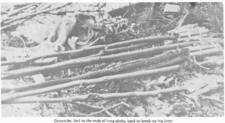
To conclude phase 1 logging analysis for the Manitowish Waters area a 1946 video of New Hampshire river drive logging will need to be viewed. Even though the mountain rivers in the video have steeper gradients than Manitowish Waters, the rapids above Sturgeon Lake also suffered terrible logjams requiring an operating log boom during the river drive era. The 1946 video is brief, but captures multiple phases of river drive logging which Wisconsin inherited from New England. From the dam gates opening, to sluicing logs, “river pigs” navigated logs through torrents of water with amazing precision. Ultimately, a log jam slows the progress of the river drive, but the resourceful use of the classic “dynamite on a stick” trick, allows the frantic pace of the river drive to resume. “River pigs’ continue to travel downstream riding logs and bateaus moving logs to the larger portions of the river, until steamboats raft the logs in huge pods to be towed over the slack water to the mill or railroads. Please watch and enjoy: https://www.youtube.com/watch?v=FJDD9VCSfpY. If you find the first YouTube video enjoyable, this link to a Maine 1930’s river drive film will be of internet as well: https://www.youtube.com/watch?v=cIKCjQdxtO0.
Arguably, loggers had to be the ultimate wilderness problem solvers. Each day, with so many variables that could go wrong: experience, resourcefulness, courage and grit were the human resources required to succeed. Now just imagine driving longer 16 foot logs for over 150 miles to mills using the Manitowish, Flambeau and Chippewa Rivers, compared to the relatively short logging run viewed in New Hampshire.
Busswell Lumber Co. train
Provider's name: Ticket to Buswell Facebook page
URL: https://www.facebook.com/TicketToBuswell/photos/a.1635977279981942.1073741829.1635294486716888/1916015445311456/?type=3&theater
Phase 2 Railroad Logging of Hardwoods and Other Timber – 1889 - 1929
During Phase 2 railroad logging Manitowish Waters transition to a secondary logging area, and was only accessed by tertiary rail routes and logging spurs. The three access rail lines to Manitowish Waters were near or at the very end of distant railroad lines. 20th century logging first depended on the Chicago Northwestern Railroad to the south; while in 1905 both the Chicago Northwestern line from Winchester and the newer Milwaukee Road Railroad to the north of the Manitowish chain arrived. Collectively these rail lines access previously uncut hardwoods and red pines while also removing white pines too distant from river systems.
The railroad era for Manitowish Waters area, shifted into high gear with the construction of the Chicago Northwestern Railroad. First, creating wagon access at Woodruff in 1888, one year later
establishing the most significant long term rail depot in the town of Manitowish, WI. Also in 1889, a less used rail stop at Powell, WI was established (59). Arguably, the most significant Manitowish Waters phase 2 logging route was the Chicago Northwestern line access to a government logging spur line for the Flambeau Lumber Company, beginning just south of the Powell depot to Little Star Lake by 1900.(60) 5 years after the Little Star Lake spur hit the southern shores of the chain, the Milwaukee Road arrived on the northern shores and surrounding lakes of the Manitowish Waters with improved and direct rail service to Rice Creek, Big Lake, Clear Lake, Buswell, and later Rest Lake.(61) 1n 1905, Chicago Northwestern Railroad matched the Milwaukee Road push to the rich timber lands north of Manitowish Waters with a new line out of Mercer WI.
The 1900 specialized logging railroad line from the Chicago Northwestern rail line to Little Star Lake has a unique history:
The rail line through the Powell Marsh area to Little Star Lake was owned by Flambeau Lumber Company-This company owned several spurs off of the Chicago Northwestern (C&NW) Ashland Division main. It was contracted by the federal government to log off the Lac Du Flambeau Indian Reservation, although the company had timber located off of the reservation as well. The mill was at Lac Du Flambeau which was connected by a spur to the C&NW main. (constructed in 1894) The C&NW had a job based in Lac Du Flambeau that hauled logs south from the O'Day and Daley operations at Mercer to the Flambeau mill. This job was referred to as the Lac Du Flambeau log job. Two large spurs branched off the C&NW main near the Vilas-Iron County line. One ran north through the Powell Marsh area to Little Star Lake operating by 1900, and the other ran south almost to the north shore of Flambeau Lake. Another large spur branched off the main about 2 miles east of Lac Du Flambeau

1903 Map of the Chicago Northwestern Railroad
Wisconsin Historic Society
WHI Image ID 89632 OCLC number 708251495
and ran into the northeast corner of the reservation. There were several small lines in the reservation's southeast corner. Operations were carried out between July of 1900 and October 5, 1913 when the mill shut down.(62)
This specialized spur was sometimes referred to as the BIA line because it was federally subsidized, officially constructed to help the Ojibwa community in Lac Du Flambeau. The Flambeau Lumber Company also was reported to have run rail lines out of Winchester south towards Manitowish Waters. The legacy of lumber companies “helping” tribal interests are mixed at best. This important spur added rail line projects east to Manitowish and Alder Lakes and northwest through the modern airport almost to Benson Lake. Many lumber companies accessed their timber resources using these rail lines.
Historically, some unscrupulous logging companies took advantage of Ojibwa lands often supported by Indian Agents interested in transitioning American Indians into commerce and economic activities of the Euro-American culture. The Ojibwa did receive opportunities to work in the short term and actually traveled off the reservation to conduct logging operation in Manitowish Waters and Winchester. In the long run, the cutover land and dam construction modified Ojibwa traditional environments making traditional hunting, fishing and gathering more challenging.(63)
1905 marked aggressive competitions for logging railroad access to the communities in the Manitowish Waters area. The Chicago Northwestern Railroad continued their aggressive development,

1910 RR Map illustrating both Chicago Northwestern and Milwaukee Road rail lines
Provider's name: Wisconsin Historical Society
URL: http://content.wisconsinhistory.org/cdm/singleitem/collection/maps/id/14747/rec/19
Digital ID: 121287 Image ID: HGX9021910P
arching northeast reaching from Mercer to Winchester to Fosterville (Winegar/Presque Isle). At the same time the Milwaukee Road Line extended its rail line west to Boulder Junction in 1903, and then in 1905 raced to Papoose Lake creating the logging boom town of Buswell.(64)
The shift northeast by the Chicago Northwestern railroad from Mercer accessed pristine hardwoods and pines, influencing new communities and created rail spurs that reached almost to Circle Lily Lake. These new rail lines linked the modern communities of Winchester and Fosterville (also referred to as Winegar and Presque Isle) to phase 2 logging transport.
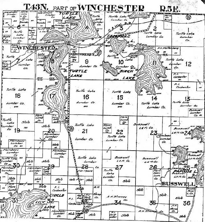
“ The Turtle Lake Company began operations out of Winchester in June of 1909. This company's rail lines fanned out in all directions reaching north into Gogebic County Mich., east to Harris and Birch Lakes, and [possibly] as far south as Circle Lily Lake. The C&NW provided rail to the company for construction of these lines. Operations ended in late 1926”. (65)
Paul Brenner describes the Vilas and Turtle Lake Companies using railroad cars to create mobile camps on both main and spur rail lines.
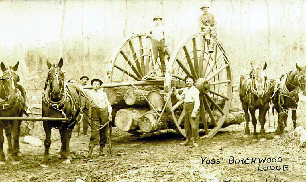
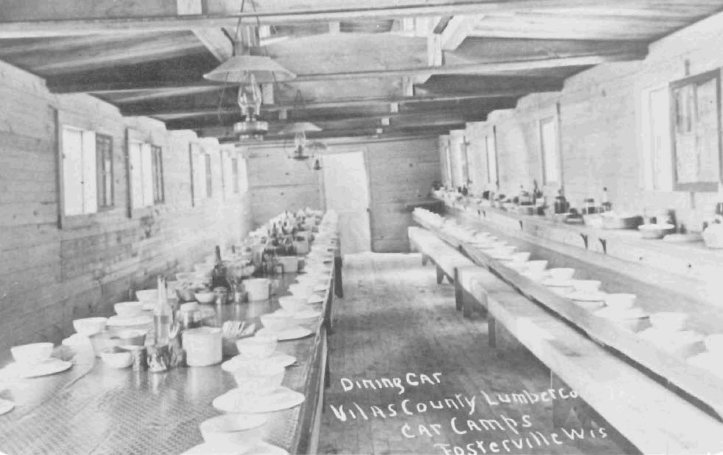
“In addition to putting permanent camps up both the Vilas County Lumber Company and the Turtle Lake Lumber Company, which was at Winchester, had what they called car camps which were camp buildings put on railroad cars. The bunkhouses the mess hall the barns and no doubt the blacksmith shop and maybe others. Whenever they got to wherever they were going to log they put in an extra spur and then the camp was set up for whatever length of time that they were going to log in that area. This picture here shows a good picture of a car camp on some lake. Again I don't know where it was. And this is the car barns from the Turtle Lake Lumber Company”(66)
Interestingly, the modern Kaysen Railroad Maps for Winchester draws different conclusions regarding logging companies and rail usage south of Winchester. Kaysen’s analysis suggest the Flambeau Lumber Company operated two lines south of Winchester, one terminating along Highway W near the WinMan Trail entrance and the Wilderness Bar; while the second Flambeau Lumber Co. line terminated one and a quarter miles south of Highway J on Circle Lily Road.(67)
Possibly the most revealing maneuver illustrating the systemic shifts of phase 2 railroad logging technology was river drive lumber giant Weyerhaeuser begining to liquidate its’ Chippewa Lumber & Boom Company (CL&B) lands.
In 1903 the Milwaukee Road constructed a line between Star Lake and Boulder Junction to serve land in the Boulder Junction area owned by CL&B. CL&B's headquarters camp is today the present village of Boulder Jct. Within a few months of the branchline's construction CL&B sold its entire holdings in the area to the Yawkey-Bissell Lbr Co. The branch was operated as a common carrier by the Milwaukee and served many other lumber companies as well.(68)

1909 Milwaukee Road Map
Wisconsin Historical Society
Digital ID: GX9028 V69 1909 P Image ID: WHI 98378
In 1905 the Milwaukee Road Line was extended from Boulder Jct. to Buswell on Papoose Lake. Buswell burned in 1910, but the line operated with a new depot at the junction of HWY K and West Papoose Lake road.(23) The Milwaukee Road line from Boulder Jct. to Buswell [area] remained in operation until 1919 serving various other logging interests and resorts on Rice Creek, Papoose Lake, Clear Lake, north of Rest Lake and Rest Lake with a spur to Riley’s hoist, due north across the bay from Camp Jorn at least by 1909. Understandably, the Yawkey-Bissell Lumber Company wished to gain access to the Manitowish Waters Chain, build a hoist on Rest Lake, to access the former Weyerhaeuser land they purchased.
“Yawkey-Bissell's trains made extensive use of the Milwaukee's lines in the area….They made use of the branch line from Buswell to Boulder Jct. in order to reach a large block of timber west of Papoose Lake. Finally, In 1909 the Milwaukee Road entered into an agreement with the A.H. Stange Lumber company …The Milwaukee Road would provide rails (7 miles initially were leased to Stange) and cars to the company. Stange only needed to put together the trains for the Milwaukee to haul to Merrill. From 1909 until 1926 there were several spurs built off of Milwaukee lines in this fashion. One spur was located at the end of the Milwaukee's Papoose Lake Branch”. (69)
In the Manitowish Waters area both the Chicago Northwestern and Milwaukee lines serviced numerous lumber companies on the same rail lines and railroad spurs. Sometimes railroad spurs (both narrow and standard gauge) were built by mills in addition to the railroads; so owners of numerous rail lines could charge loggers for a single job. With different lumber companies using the same rail transport, identifying logs required stamp hammers like the hammers used on river drive logging. The mills sorted the logs according to ownership identified by stamps. The lumber mills would then back feed the data on specific logging companies’ timber footage to railroads to generate accurate transportation charges. (70) Early, plat maps reveal multiple logging companies using the same spur lines in the Manitowish Waters area around Rest Lake. (71)
Michael Dunn provides precise insights regarding phase 2 rail and water transport to rail hoists on the Manitowish Waters chain:
Hardwood logs were partially dried to ensure their staying afloat until another little lake boat, like the gasoline powered Skiddoo, could raft them to the two landings for loading on railroad cars. From the Star Lake spur track there also radiated little railroad spurs over which lightweight but standard gauge "Peggy" locomotives (geared locomotives, most likely of the shay or screwdriver variety) pulled in loads of logs from the woods; some of these temporary lines ran as far as Alder and Benson lakes. Big logging activity ceased between 1911 (when the last Yawkey-Bissell activity ceased; that firm's last local camp was near Mud Lake, now Fawn) and 1914 (when the last logs had been shipped from the hoist at Star Lake). In 1919 the Milwaukee Road removed its track along the north side of the chain; the spur to the C&NW was quietly taken up around the same time. (72)

Buswell mill rail stop for off loading logs into pond
Provider's name: Ticket to Buswell Facebook page
URL: https://www.facebook.com/TicketToBuswell/photos/a.1635977279981942.1073741829.1635294486716888/1912853948960939/?type=3&theater
Logging camps in the Manitowish Waters area were of varying size and composition. Cut trees were transported by rail to lumber mills both near and far. The most storied and closest local lumber mill was Buswell on the southwest shore of Papoose Lake. Buswell was just a few miles north of the northeast corner of Manitowish Waters Township, and sprung-up immediately upon the arrival of the Milwaukee Road Railroad. Only in operation for 5 years, this short-lived community has become a “historic pop-culture” favorite, with a dedicated Facebook page: “Ticket to Buswell”. Early Island Lake pioneer, Abe LaFave had strong ties to Buswell and his children attended the Buswell School. LaFave family histories are populated with stories of travel up Rice Creek to Buswell. After the devastation of the 1910 fire the Buswell Lumber Company fell upon hard times liquidating lands to the state of Wisconsin.(73) After the fire their railroad locomotive was rated in poor condition and timber sales to Wausau were contested and brought before the Wisconsin Railroad Commission in 1912.(74) The budding town of Buswell had great promise to grow and prosper, but it fell prey to the most dangerous force in the Northwoods, FIRE.(75)
At this point, the timeline of phase 2 logging in the Manitowish Waters area is mostly complete. More specifics regarding logging communities, mills, practices, technologies and traditions need to be explored, utilizing the thorough document by historians Paul Brenner, Michael Dunn and Malcolm Rosholt. Their collective historical writings, images and narratives will further illuminate phase 2 logging culture in the Manitowish Waters area and the Chippewa River basin. In the quest for brevity, no further analysis of phase 2 logging will included. Interested readers are highly encouraged to explore more local logging history from Brenner and Dunn at: http://mwlibrary.blogspot.com/search/label/logging. While, Malcolm Rosholt’s publication, Lumbermen on the Chippewa, is fantastically illustrated, supported by strong research, and is arguably the most comprehensive publication on Wisconsin northwoods logging, found at: http://content.mpl.org/cdm/compoundobject/collection/mcml/id/3757/rec/1. (76)
Phase 3 Logging Truck, Tractor, and Road - 1920-Present
In the transition from phase 2 logging to phase 3 logging Wisconsin government ramped-up their efforts to rein-in timber trespass and regulate logging practices. During the Gilded Age of late 19th century, government officials often assumed the traditional laissez-faire logging enforcement policies. Both the “famed” Eau Claire land agent Henry Putnam and University benefactor Ezra Cornell had battled timber stealers with mixed results since the 1860’s, due largely to a lack of honest governmental engagement. Upon the dawn of the 20th century the new Progressive political movement energized Wisconsin’s Republican Party to take action, enacting stiffer timber trespass laws and fund active enforcement with new Department of Forestry rangers. As Wisconsin was buying old timber lands and consolidating government lands to create a new Wisconsin Forest Reserve (later the Northern Highland Forest) timber plunders continued to target government lands.(77) Original State Forester E. M. Griffith drove a modern vision of forestry and other resource management, based on data analysis, best practices and science. Griffith’s defining work mirrored national efforts of environmental leaders like Gifford Pinchot, and utilized forestry management models from Europe and New York State.
From 1911 to 1922, Manitowish Waters had a full time specially trained forest ranger, who completed a rigorous 2 year curriculum.(78)(79) The construction of the Rest Lake Ranger Station and Fire Tower established a new professional forestry presence and helped launched the tradition of community environmental conservation in Manitowish Waters. Established one year after the lumber community of Buswell burned, the new ranger and his men were certainly welcomed to help protect our community’s prized forests and properties. The new systematic fire prevention and suppression practices Griffith developed were also supported by local residents.(80) In Manitowish Waters, fire prevention and suppression has always been a community effort. Some of the earliest properties on the chain still have operating fire bells. “A Fire Bell in the Night” struck deep fear and was a call to action. For a long time, alerting your neighbors for help was the only hope to stop a “Buswell like” event. Consequently, Manitowish Waters created a private fire company run by town citizens, which remains as one of the few private fire companies in the state of Wisconsin.
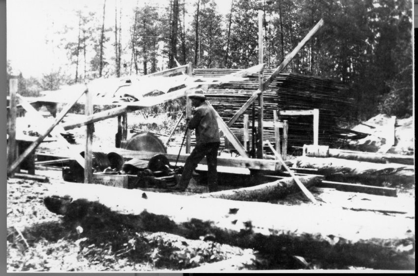
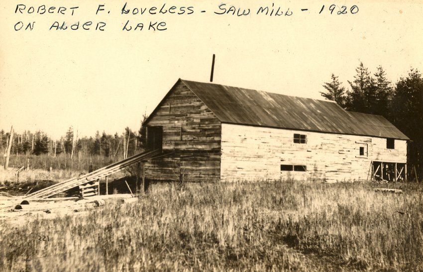
Robert Loveless Alder Lake saw mill c. 1920
Loveless Collection held in Manitowish Waters Historical Society
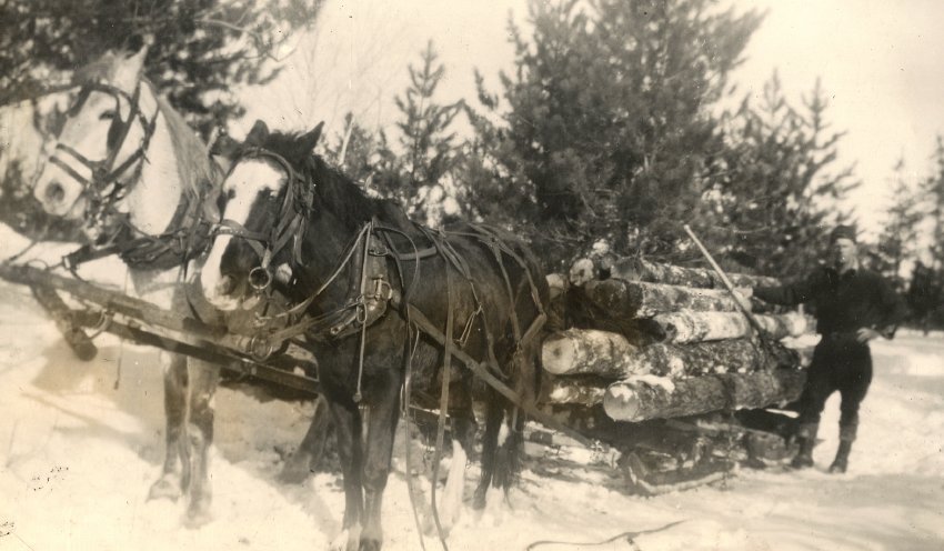
Phase 3 logging marked the reemergence of Manitowish Waters as a modest logging hub shortly after World War I. Notably, the scale of logging operations were smaller during phase 3, with tractors, trucks and bull dozers replacing railroads for log transport from the woods. Often family operations, sawmills varied in size during phase 3, sometimes operating portable mills.(81) With the large tracts of hardwoods gone, phase 3 loggers harvested remaining timber, second growth, and began to target poplar as pulpwood for paper mills. Small temporary logging camps accessed by trucks dotted the Northwoods, as loggers moved from one cut to another. In Manitowish Waters, residents had the unique opportunity to use pike poles to reach up to 20 feet in lakes to retrieve logs that sunk during earlier steamboat rafting operations. During the prosperity boom of the 1920’s the last of the phase 2 logging ended and phase 3 loggers were in full swing, meeting lumber demands for a growing tourist community. After the stock market crash, the 1930’s ushered in hard times for the Northwoods, but some local loggers still continued operations to fulfill local demand. Especially in hard times, the community benefited from local timber processed at the Loveless Mill.
One of the greatest logging and lumber traditions in the Manitowish Waters area was the Loveless families’ Phase 3 logging enterprise on Alder Lake. Robert Loveless typified Northwoods pioneers during the logging, early resort and guiding eras. Loveless family journals and accounts portray Robert Loveless as a highly resourceful young adventure, who reached the shores of Big Trout Lake in the dead of winter of 1891, with 36 cents. Humbly, avoiding drinking and brawling, Loveless’ worked diligently as a builder, hunter, lumber camp cook, trapper, market fisherman and guide.(82)
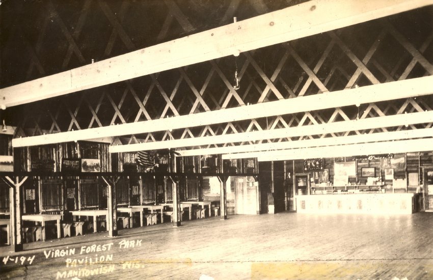
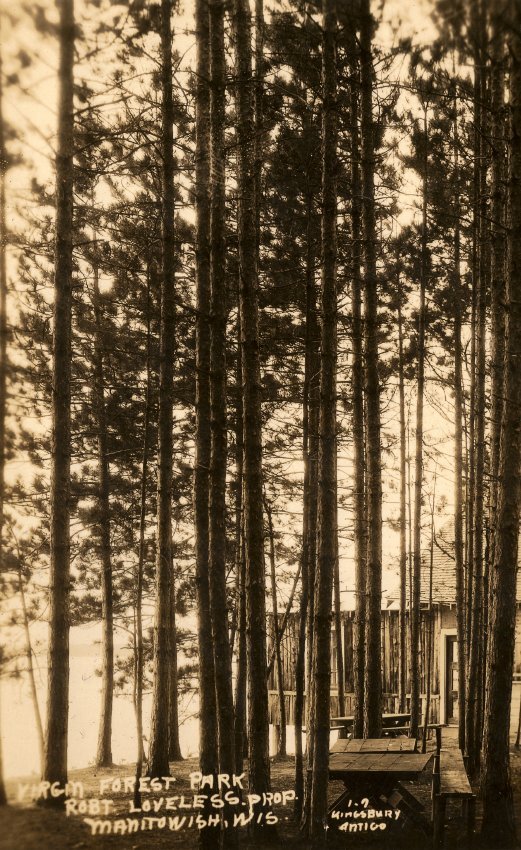
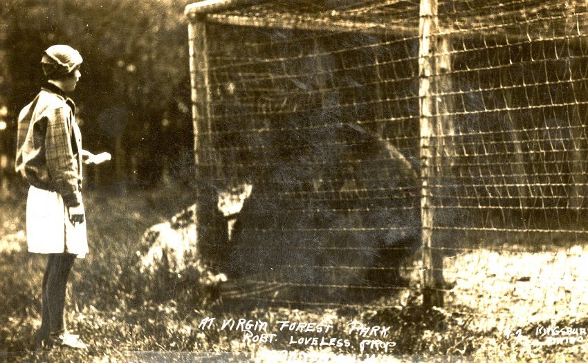
Early on, Loveless stood out from his peers as a gifted woodsman, who could be relied upon. Consequently, investors Richard Southgate and Marvin Hugitte selected Loveless as caretaker for their uniquely ambitious railroad/canal retreat on Little Trout Lake. Loveless steadfastly oversaw this property for 30 years, ultimately empowering him to purchase personal property on the north side of Alder Lake.(83) What Loveless called his Virgin Forest Park, will remain mostly uncut, creating a towering forest similar to those he witnessed in 1891. His phase 3 sawmill, dancehall, and resort on the northwest shore of Alder Lake illustrated that Loveless’ talents as a woodsman extended into a variety of entrepreneurial ventures.
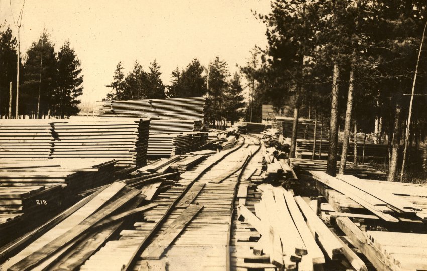
Phase 3 loggers needed a local mill to process their lumber and Robert Loveless had the perfect operation. Able to accommodate logs delivered by both water and roads his family created a small but well-engineered system. Logs floated or skidded on ice to the mill pond were efficiently moved by log hoist to the saw mill. Road access was also available to the Loveless lumber enterprise, a track systems could move logs and processed lumber overland to organized unprocessed logs and finished lumber.
Michael Dunn identifies the Loveless sawmill as a multigenerational business and unique to meet regional lumber demands: “The lone sawmills to operate after that era in the area were operated by Bob Loveless, who cut timber in the few pockets of virgin forest during the 1920's, and Marvin Loveless, who ran a small mill into the 1940's or 1950's.” (84)
Mill pond and chain driven track into the Loveless Sawmill
Loveless Collection from the Manitowish Waters Historical Society
The childhood insights of Ella (Loveless) Kassien illuminates the operation and impacts of her father’s mill, in her narrative, “Milling Around”:
Milling Around. Virgin Forest Park began to change when dad built a two-story saw mill at Alder Lake. He hired a half dozen or so men to cut timber and haul logs on horse-drawn sleds. So huge were the trees that often just one log could fit on a sled. Dad also built a dam across the river outlet of Alder Lake. Later water held back by the dam formed a “mill pond,” a cove where booms of chained logs were held for milling.
One by one, the floating logs were hoisted 12 feet on a chain-driven track into the mill, where they slid down a chute to a deck. The logs then moved through the mill on a second track, as first a circular head saw and then smaller chainsaw cut the logs into planks. The lumber was then stacked outside the Mill until sold. Many old buildings around Boulder Junction, Lac Du Flambeau, and Manitowish Waters began at the Loveless mill.(85)
Current owners of the sawmill site, Tom & Michelle Baer have gone to great lengths to document and preserve the traditions of the Loveless family. At Baer’s Mill Point Resort the trees remain largely uncut, with the mill pond and sawmill site featured as prized elements of the property. Images from the Loveless family’s life on Alder Lake are proudly displayed at Mill Point Resort, and guests can celebrate their vacation in the context of a unique northwood’s tradition.
Phase 3 logging ultimately transitions into modern logging practices after World War II. Driven by unprecedented demand of the post war boom, both logging and Manitowish Waters began to grow. Phase 3 loggers and mill operators will continue into the 1950’s in Manitowish Waters, and a few locals continue these traditions today.
Conclusion
The challenge of concluding Logging Impacts on the Manitowish Waters Area and Land Policy is no small task. This defining chapter of Manitowish Waters’ history is both complex and lengthy. The best solution to this challenge may be found in my backyard. Immediately where the outlet of the Trout River enters Alder Lake is in full view as I write from my home. Starting in 1888, white pines would be driven and/or rafted by paddlewheel steam boats from upstream of Alder Lake to the Rest Lake dam, attempting to fulfill the insatiable demand of Weyerhaeuser’s phase 1 river drive logging operations in Chippewa Falls. In the early 1900’s, across Alder Lake, on the west shore, a railroad spur line entered by the modern DNR campsite. Logs were rafted by steamboat and/or skidded by horses to this phase 2 railroad spur line, establishing one of the most distant spur lines from the Chicago Northwestern Railroad. Finally, shortly after the railroads departed from Manitowish Waters and just after World War I, Robert Loveless created his Phase 3 sawmill on the northwest corner of Alder Lake. Next to the outlet of the Trout River on Alder Lake for 2 generations the Loveless family will support area logging and consumers by milling local lumber. Importantly, Robert Loveless broke the strangle-hold of lumber companies and speculators on pioneers, by completing a land contract from the Wisconsin Bluegrass Land Company for 80 acres on Government lots 3 & 4 of section 25 on the north shore of Alder Lake in 1909. Adding additional acres from lot 2 of section 25 in 1910. Typifying a pioneer family’s struggles, hard work, ingenuity, and vison; ultimately achieving the American Dream.
End Notes
References to Sources
1 http://dnr.wi.gov/wnrmag/html/stories/2004/feb04/forest.htm. Wisconsin Department of Natural Resources. Randall E. Rohe. Retrieved 1-26-2018.
2 Interview. Craig Moore. Eagle River Historical Society Museum. Eagle River, WI 12-21-2017.
3 http://images.library.wisc.edu/WI/EFacs/transactions/WT199101/reference/wi.wt199101.i0011.pdf. Transactions of the Wisconsin Academy of Sciences, Arts and Letters volume 79, No. 1. State of Wisconsin Collections. pp 13-31. Retrieved 2-15-2018.
4 http://images.library.wisc.edu/WI/EFacs/transactions/WT199101/reference/wi.wt199101.i0011.pdf. Transactions of the Wisconsin Academy of Sciences, Arts and Letters volume 79, No. 1 State of Wisconsin Collections. p.61-71. Retrieved 2-15-2018.
5 http://images.library.wisc.edu/WI/EFacs/transactions/WT199101/reference/wi.wt199101.i0011.pdf. Transactions of the Wisconsin Academy of Sciences, Arts and Letters volume 79, No. 1. State of Wisconsin Collections. pp 13-31. Retrieved 2-15-2018.
6 Interview. Craig Moore. Eagle River Historical Society RR Depot 12-21-17
7 http://digicoll.library.wisc.edu/SurveyNotes/SurveyInfo.html. Land Survey Information. Board of Commissioners of public Lands. Retrieved 2-15-2018.
8 https://www.wisconsinhistory.org/Records/Image/IM115264. The Native Vegetation of Wisconsin : at the Time of the Original Land Survey. Wisconsin Historic Society. Retrieved 2-15-2018.
9 https://mwhistory.org/menu-page-for-maps-and-journals/maps-folder/original-survey-maps-from-the-manitowish-waters-area-1860s/manitowish-waters-42-05-east-1862/. Original Survey maps and note books. 1862. Manitowish Waters Historical Society. Retrieved 2-3-18.
10 Gates, Paul Wallace. The Wisconsin Pine Lands of Cornell University. The State Historical Society of Wisconsin: Madison. 1943. Pages 73. Retrieved 2-15-2018.
11 http://chippewa.com/dunnconnect/news/local/history/cornell-connection---new-york-university-founder-picked-up/article_01bdab05-9c99-542a-9bfb-eaddf72e07b4.html . Cornell connection - New York university founder picked up Wisconsin lumber land — on the cheap. Retrieved 2-15-2018.
12 Gates, Paul Wallace. The Wisconsin Pine Lands of Cornell University. The State Historical Society of Wisconsin: Madison. 1943. Pages 106-107
13 http://content.wisconsinhistory.org/cdm/compoundobject/collection/maps/id/19986/rec/1. Map of Iron County Wisconsin. Wisconsin Historical Society. Digital ID: BG141816R41898. P 26. Retrieved 2-3-2018.
14 Gates, Paul Wallace. The Wisconsin Pine Lands of Cornell University. The State Historical Society of Wisconsin: Madison. 1943. Pages 74-75.
15 Ibid., 115.
16 Fries, Robert F. Empire In Pine the Story of Lumbering in Wisconsin. William Caxton Ltd: Sister Bay WI. Page 162.
17 Gates, Paul Wallace. The Wisconsin Pine Lands of Cornell University. The State Historical Society of Wisconsin: Madison. 1943. Page 200.
18 Ibid.,151-154.
19 Fries, Robert F. Empire In Pine the Story of Lumbering in Wisconsin. William Caxton Ltd: Sister Bay WI. Page 164.
20 Gates, Paul Wallace. The Wisconsin Pine Lands of Cornell University. The State Historical Society of Wisconsin: Madison. 1943. Pages 102-105.
21 Gates, Paul Wallace. The Wisconsin Pine Lands of Cornell University. The State Historical Society of Wisconsin: Madison. 1943. Pages 211-212
22 http://riptrack.net/wisconsin-19th. Wisconsin railroad timeline: 19th century. Retrieved 1-26-2018.
23 https://www.immigrantentrepreneurship.org/entry.php?rec=239#_ednref29. Immigrant Entrepreneurship. Fredrick Weyerhaeuser. Retrieved 1-26-2018.
24 http://mwlibrary.blogspot.com/search/label/logging. Looking back at the logging years. Koller Library. Michael J. Dunn, III. Retrieved 1-26-2018.
25 Ibid.
26 https://mwhistory.org/2016/wp-content/uploads/2017/01/Allen-selected-journal-1878-1879-new-1.pdf.. Selections from Captain C. J. Allen Journal House of Rep. 45 Congress 1878-1879. Manitowish Waters Historical Society. Retrieved 2-3-18. Page 40.
27 https://mwhistory.org/secretary-of-war-journal-2nd-rest-lake-dam-1880/. Secretary of War Journal-2nd Rest lake Dam, 1880. Manitowish Waters Historical Society. Retrieved 2-3-18. Page 1607.
28 https://mwhistory.org/the-wisconsin-laws-and-joint-relolutions-1899-upper-trout-river-dam/. Wisconsin Laws and Joint Resolutions. Manitowish Waters Historical Society. Retrieved 2-3-18. Page 603-604.
29 http://mwlibrary.blogspot.com/search/label/history. A look back: the 19th century and earlier. Koller Library. Michael J. Dunn, III. Retrieved 1-26-2018.
30 http://mwlibrary.blogspot.com/search/label/devine%20family. low in the grave he lay. Koller Library. Retrieved 1-26-2018.
31 https://mwhistory.org/wisconsin-reports-164-cases-determined-by-the-supreme-court-of-wisconsin-1916-1917-rest-lake-dam/. Wisconsin Reports 164/Cases Determined in the Supreme Court of Wisconsin 1916-1917. Chippewa and Flambeau Improvement Co. Appellant, versus Wisconsin Railroad Commission, Respondent. Manitowish Waters Historical Society. Page 105-123. Retrieved 1-27-18.
32Gates, Paul Wallace. The Wisconsin Pine Lands of Cornell University. The State Historical Society of Wisconsin: Madison. 1943. Pages 133.
33 Doolittle, Shirley. Boulder Junction The Early Years: 1880 to 1950. Published by Friends of the Library, Boulder Junction WI, 1996. P. 12.
34 Fries, Robert F. Empire In Pine the Story of Lumbering in Wisconsin. William Caxton Ltd: Sister Bay WI. Page 155.
35 Register of Deeds, Eagle River Courthouse. Eagle River WI. Vol. 20. Page 69. 1902.
36 Doolittle, Shirley. Boulder Junction The Early Years: 1880 to 1950. Published by Friends of the Library, Boulder Junction WI, 1996. P. 12.
37 http://mwlibrary.blogspot.com/search/label/logging. Looking back at the logging years. Koller Library. Michael J. Dunn, III. Retrieved 1-26-2018.
38 https://mwhistory.org/2016/wp-content/uploads/2017/01/1914-State-of-Wisconsin-Railroad-Com-Rest-Lake-Dam.pdf. Railroad Commission-State of Wisconsin: Rest Lake Dam 1914. Manitowish Waters Historical Society. Retrieved 2-4-18. Page 441.
39 http://mwlibrary.blogspot.com/search/label/logging. Looking back at the logging years. Koller Library. Michael J. Dunn, III. Retrieved 1-26-2018.
40 https://mwhistory.org/wisconsin-reports-164-cases-determined-by-the-supreme-court-of-wisconsin-1916-1917-rest-lake-dam/. Wisconsin Reports 164/Cases Determined in the Supreme Court of Wisconsin 1916-1917. Chippewa and Flambeau Improvement Co. Appellant, versus Wisconsin Railroad Commission, Respondent. Manitowish Waters Historical Society. Page 112. Retrieved 1-27-18.
41 Ibid.
42 Interview. Cynthia Stiles. Lac Du Flambeau Historic Preservation Office. Lac Du Flambeau, WI. 2-16-2018.
43 https://mwhistory.org/shields-magazine-1890-journal-from-presque-isle-to-manitowish-station-published-in-1907/. Shields Magazine:1890 Journal from Presque Isle to Manitowish Station-published in 1907. Manitowish Waters Historical Society. Retrieved 2-4-18. Page 87.
44 http://mwlibrary.blogspot.com/search/label/logging. Looking back at the logging years. Koller Library. Michael J. Dunn, III. Retrieved 1-26-2018.
45 http://mwlibrary.blogspot.com/search/label/logging, Paul Brenner, interview continued. Koller Library. Paul Brenner. Retrieved 2-4-2018.
46 http://mwlibrary.blogspot.com/search/label/logging. Looking back at the logging years. Koller Library. Michael J. Dunn, III. Retrieved 1-26-2018.
47 http://mwlibrary.blogspot.com/search/label/logging, Paul Brenner, interview continued. Koller Library. Paul Brenner. Retrieved 2-4-2018
48 https://mwhistory.org/2016/wp-content/uploads/2017/02/Forest-and-Stream-1895-logging-trapping-Buck.pdf. How Fur Is Caught II. Forest and Stream. 1895. Manitowish Waters Historical Society. Page 486. Retrieved 2-5-18.
49 Ibid.
50 https://mwhistory.org/2016/wp-content/uploads/2017/02/1895-foreststream-logging-trapping-star-lake.pdf. How Fur Is Caught V. Forest and Stream. 1895. Manitowish Waters Historical Society. Page 588. Retrieved 2-5-18.
51 http://mwlibrary.blogspot.com/2012/06/history.html. "History...". Koller Library Dunn, Michael. Retrieved 6-7-22.
52 http://mwlibrary.blogspot.com/search/label/logging. Paul Brenner’s Interview-the Finale. Koller Library. Paul Benner. Retrieved 2-5-2018.
53 Doolittle, Shirley. Boulder Junction The Early Years: 1880 to 1950. Published by Friends of the Library, Boulder Junction WI, 1996. pp. 18-19.
54 https://mwhistory.org/2016/wp-content/uploads/2017/02/Forest-and-Stream-1895-logging-trapping-Buck.pdf. How Fur Is Caught II. Forest and Stream. 1895. Manitowish Waters Historical Society. Page 486. Retrieved 2-5-18.
55 http://xroads.virginia.edu/~HYPER/TURNER/. The Significance of the Frontier in American History. Fredric Jackson Turner. Retrieved 2-11-2018.
56 Ibid.
57 http://mwlibrary.blogspot.com/search/label/logging. Looking back at the logging years. Koller Library. Michael J. Dunn, III. Retrieved 1-26-2018.
58 http://mwlibrary.blogspot.com/search/label/logging, Paul Brenner, interview the finale. Koller Library. Paul Brenner. Retrieved 2-4-2018
59 http://mwlibrary.blogspot.com/search/label/logging, Paul Brenner, interview continued. Koller Library. Paul Brenner. Retrieved 2-4-2018.
60 http://content.wisconsinhistory.org/cdm/singleitem/collection/maps/id/1572/rec/4. Lakes tributary to G.W. Buck & Son resorts. Wisconsin Historical Society. Image # 97107. Retrieved 1-26-2018.
61 http://content.wisconsinhistory.org/cdm/singleitem/collection/maps/id/1857/rec/13. Star lake country northern Wisconsin. Wisconsin Historical Society. Image # 98378. Retrieved 1-26-2018.
62 http://sassmaster.tripod.com/vilas.html. Wisconsin Logging Railroads. Vilas County. Timothy Sasse. Retrieved 1-26-2018.
63 http://images.library.wisc.edu/WI/EFacs/transactions/WT199101/reference/wi.wt199101.i0014.pdf. Ronald Satz. Wisconsin Historical Society Digital Collections. Chippewa Treaty Rights. 1991. Page 74-75.
64 http://sassmaster.tripod.com/vilas.html. Wisconsin Logging Railroads. Vilas County. Timothy Sasse. Retrieved 1-26-2018.
65 http://sassmaster.tripod.com/vilas.html. Wisconsin Logging Railroads. Vilas County. Timothy Sasse. Retrieved 1-26-2018.
66 http://mwlibrary.blogspot.com/search/label/logging. Paul Brenner Interview, continued. Koller Library. Retrieved 1-26-2018.
67 http://content.wisconsinhistory.org/cdm/singleitem/collection/maps/id/2786/rec/9. Papoose Lake. James P. Kaysen. Wisconsin Historical Society. Image # unknown. Retrieved 1-26-2018.
- http://sassmaster.tripod.com/vilas.html. Wisconsin Logging Railroads. Vilas County. Timothy Sasse. Retrieved 1-26-2018.
69 Ibid
70 Interview: Craig Moore. Eagle River Historical Society Museum. Eagle River, WI 12-21-2017.
71 http://content.wisconsinhistory.org/cdm/compoundobject/collection/maps/id/18155/rec/43. Vilas County. Wisconsin Historical Society. Digital Identifier RGZ9021915-286.. Retrieved 1-26-2018. Page 283.
72 http://mwlibrary.blogspot.com/search/label/logging. Looking back at the logging years. Koller Library. Michael J. Dunn, III. Retrieved 1-26-2018.
73 http://images.library.wisc.edu/WI/EFacs/USAIN/RSF/RSF191112/reference/wi.rsf191112.i0012.pdf. Wisconsin. State Board of Forestry / Report of the state forester of Wisconsin for 1911 and 1912. State of Wisconsin Collection. p. 102. Retrieved 2-7-2018.
74 http://images.library.wisc.edu/WI/EFacs/USAIN/RSF/RSF191112/reference/wi.rsf191112.i0009.pdf. Wisconsin. State Board of Forestry / Report of the state forester of Wisconsin for 1911 and 1912. State of Wisconsin Collection. p. 43. Retrieved 2-7-2018.
75 http://images.library.wisc.edu/WI/EFacs/USAIN/RSF/RSF191112/reference/wi.rsf191112.i0009.pdf. Wisconsin. State Board of Forestry / Report of the state forester of Wisconsin for 1911 and 1912. State of Wisconsin Collection. p. 29. Retrieved 2-7-2018
76 http://content.mpl.org/cdm/compoundobject/collection/mcml/id/3757/rec/1. Lumbermen on the Chippewa. McMillan Memorial Library. Malcolm Rosholt. 1982. Retrieved 2-7-2018
77 http://images.library.wisc.edu/WI/EFacs/USAIN/RSF/RSF190910/reference/wi.rsf190910.i0033.pdf. Wisconsin. State Board of Forestry Report of the state forester of Wisconsin for 1909 and 1910. Wisconsin Historical Society. p. 133. Retrieved 2-7-2018.
78 https://mwhistory.org/2016/wp-content/uploads/2017/03/1911-12-Report-to-State-Forester-Rest-L-Ranger-Station.pdf. State Forest Reserves. Report of the State Forester of Wisconsin for 1911 and 1912. 1913. .P. 51. Retrieved 2-15-2018.
79 https://mwhistory.org/2016/wp-content/uploads/2017/03/1921-22-Biennial-Report-State-Conserv-Com-Rest-Lake-Ranger-Station.pdf. State Conservation Commission of Wisconsin for the Fiscal years of 1921 to 1922. .P. 16. Retrieved 2-15-2018.
80 http://images.library.wisc.edu/WI/EFacs/USAIN/RSF/RSF191112/reference/wi.rsf191112.i0011.pdf. Wisconsin. State Board of Forestry / Report of the state forester of Wisconsin for 1911 and 1912. State of Wisconsin Collection. p. 80-97. Retrieved 2-7-2018.
81 http://dnr.wi.gov/wnrmag/html/stories/2004/feb04/forest.htm. Wisconsin Department of Natural Resources. Randall E. Rohe. Retrieved 1-26-2018.
82 https://mwhistory.org/robert-loveless-journal-1891-1925/. Robert Loveless Journal 1891-1925. Manitowish Waters Historical Society. Retrieved 2-5-18.
83 Ibid.
84 http://mwlibrary.blogspot.com/search/label/logging. Looking back at the logging years. Koller Library. Michael J. Dunn, III. Retrieved 1-26-2018.
85 https://mwhistory.org/2016/wp-content/uploads/2017/10/Alder-Lake-Story.pdf. Growing-up at Alder Lake. Ella Kassien. Manitowish Waters Historical Society. Page 7. Retrieved 2-5-18.
Research & Additional Resources
- History of Gruettner and Flancher family’s time in Manitowish Waters.
- Forest and Stream: How Fur is Caught II – 1895
- Forest and Stream: How Fur is Caught V Sayner-Star Lake – 1895
- Forest and Stream: How Fur is Caught I – 1895
- Forest and Stream: How Fur is Caught IV – 1895
- The Wisconsin Laws and Joint Relolutions 1899-Upper Trout River Dam
- USGS Water Power in Northern Wisconsin 1906-Regional dams and basin data
- Outers Magazine- “Fish That Bite and Get Away” by Harold W. Pripps with early details on the Turtle Flambeau Flowage
- Outers Magazine-“Up to Lost Lake and Back -A Fishing Trip Without Fish” 1918 by Harold W. Pripps
- Rintelman’s Journal-Focusing on Clear Lake with detailed histories of the Devine Family and early tourism.
- Railroads in the Northwoods: a modern map of historic railroads
- Growing Up At Alder Lake a Journal from the Robert Loveless Family 1991
- The Transition from Logging Camp to Resort-Paul Brenner
- Reminiscence Growing Up on Alder Lake by Ella Loveless Kassien
- “A Look Back” -An overview of Manitowish Waters history from 1600-1999 by Michael Dunn III
- Paul Brenner receives Fixmer Award 2000
- Michael Dunn’s notes on lumber company complexes and distinctive equipment.
- Dr. & Mrs E.A. Flancher and the Peggy Line by Michael Dunn
- A Thumbnail Sketch of Logging Activities around the Manitowish Waters Area….by Michael Dunn
- “A Thumbnail Sketch of Logging Activities in the Manitowish Waters Area”. by Michael Dunn III
- Michael Dunn cover letter to 2017 narratives